FOSI Newsletter #78 December 2017
In this issue
One Mile Dunwich - Wild Bird Alert!
Moreton Bay’s Wetlands of International Importance
Foxes continue to be baited in large numbers
Koala Count 2017
Moreton Bay Water Quality Improves for 2017
The War on Cane Toads
Did the Norfolk Great Wave occur on North Stradbroke Island?
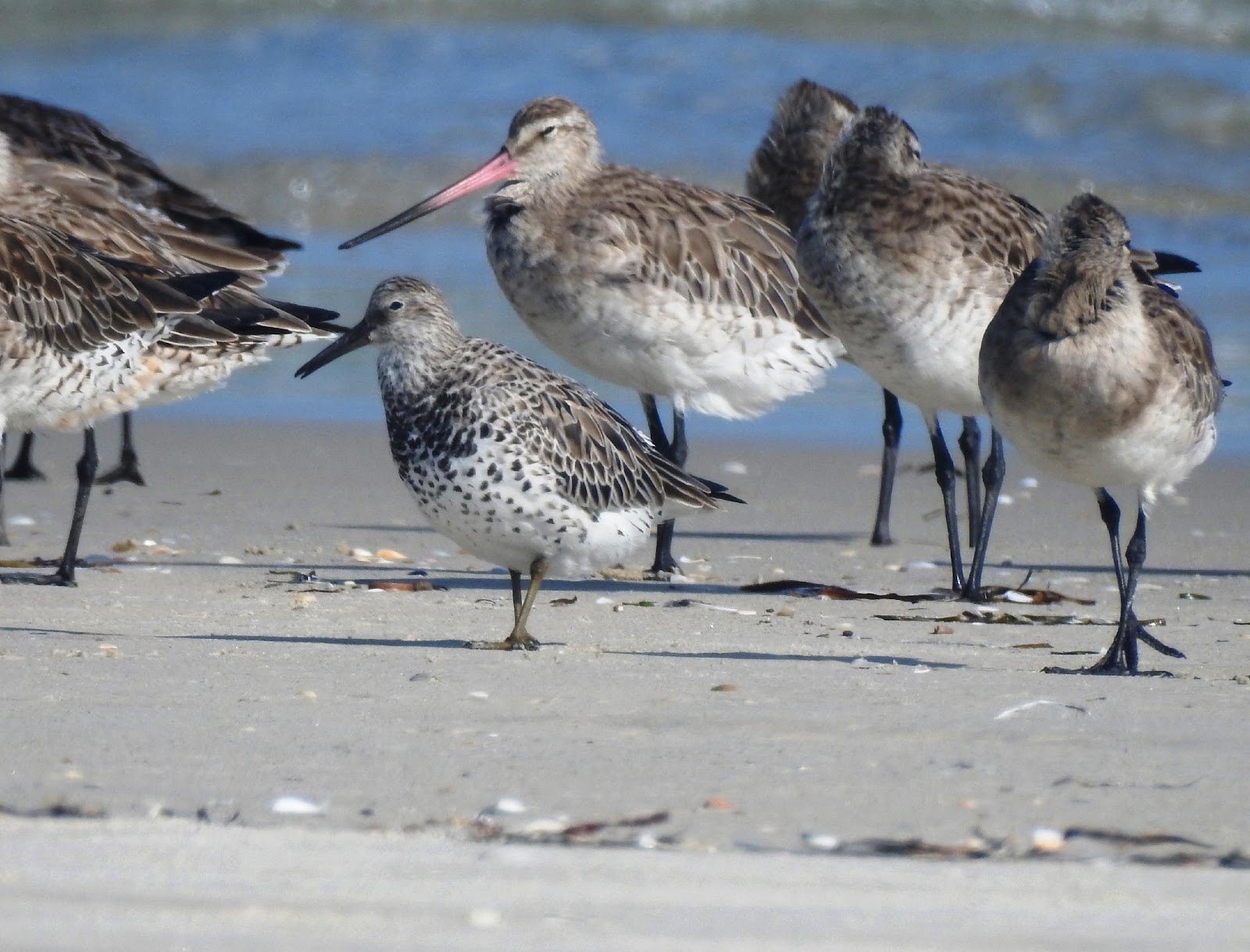
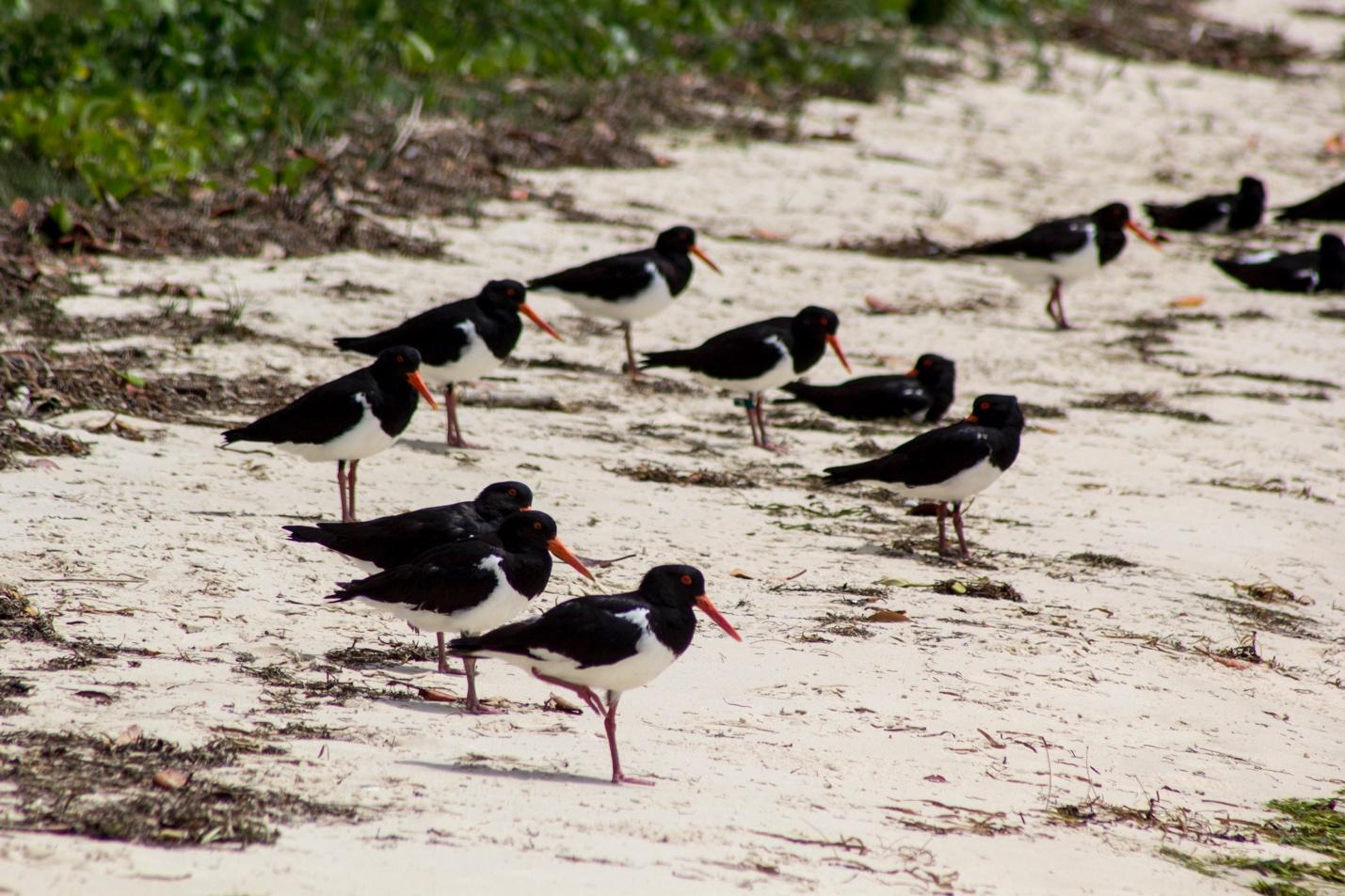
One Mile Dunwich - Wild Bird Alert!
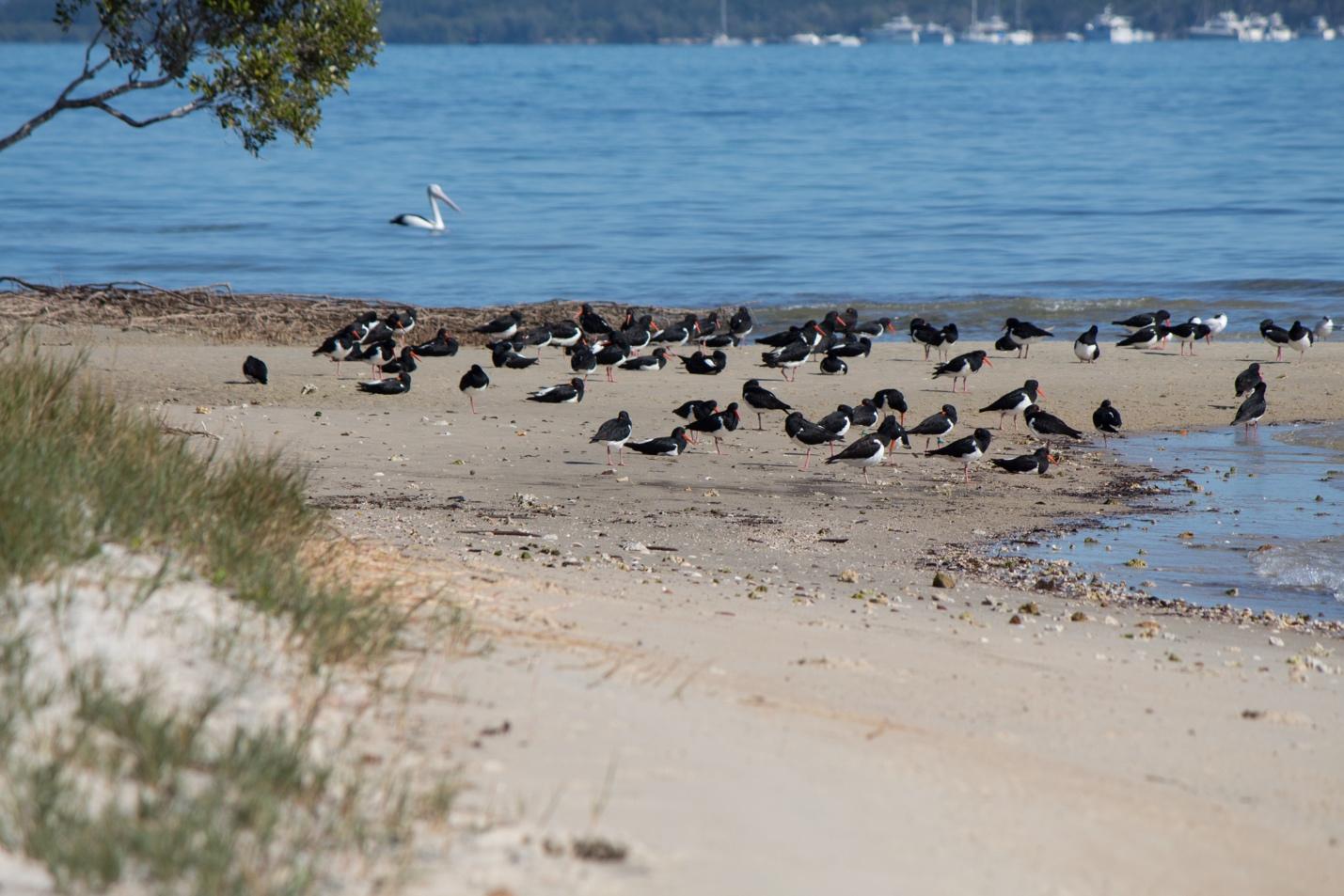
Pied Oystercatchers and terns on the Bradburys Beach high tide roost near the One Mile water taxi terminal.
One Mile Dunwich - Wild Bird Alert!
Riding the ferries and water taxis to the island is always a pleasure, but travellers coming and going at the One Mile ferry terminal have the extra bonus of passing through a wild bird hotspot. Before the ferry ties up, observant passengers can look out for the Eastern Osprey nest on a navigation buoy and admire the pelicans and cormorants expertly perched atop mooring poles. As travellers disembark, flitting above them in the terminal are Welcome Swallows attending their mud nests tucked among the roof trusses. And to both sides of the ferry terminal lie tidal wetlands, fringing mangrove forest and the small sandy rim of Bradburys Beach abutting Polka Point’s rocky shore. All these places provide living spaces for more wild birds… so important they are recognised as a Habitat Protection Zone in the Moreton Bay Marine Park.
At low tide the muddy sand flats are exposed – these are rich feeding grounds for shorebirds. Among the special birds that can been seen on the One Mile wetlands from the water taxi are the fabulous migratory shorebirds which fly from Russia, Alaska, Mongolia and Canada along the East Asian-Australasian Flyway to summer in Australia. Quandamooka/Moreton Bay is often their first touch-down point on our continent; the bay is recognised under the international Ramsar Treaty as a special habitat for migratory birds. The Moreton Bay Ramsar site traces the shoreline of North Stradbroke Island and includes about 50% of the interior of the Island.
Migratory shorebirds or waders spend their six or so months in Australia building up their bodies for their return autumn trip to northern Asia and Canada to breed in the tundra areas. Commonly spotted are the Far Eastern Curlews – the largest wader and notable for its long, curved beak - along with their smaller companions, the Bar-tailed Godwits and Whimbrels. At low tide, day and night, these birds feed voraciously on worms, insects and crustaceans side-by-side with the island’s resident water and shore birds. Look out for the flocks of resplendent Royal Spoonbills, skulking Nankeen Night Herons, Caspian Terns, busy ibis, egrets, gulls and Masked Lapwings. In the fringing forest of Grey Mangroves, Sacred Kingfishers perch and honeyeaters feed on nectar and insects.
At high tide when their feeding grounds are covered the shorebirds gather on Bradburys Beach and other protected roosts around Moreton Bay. These ‘high tide roosts’ are the bird’s open-air bedrooms where the birds rest and sleep. The birds display what is known as site fidelity – returning time and time again to favoured places that really suit them. On Bradburys Beach the visiting waders sometimes roost alongside the resident Pied Oystercatchers, resplendent in their black and white plumage offset by red beak, legs and eye rings. Research has shown that Bradburys Beach is an internationally significant roosting site for these beautiful birds. Friends of Stradbroke Island has been working with the Queensland Waders Study Group to gather data on the oystercatchers that use this roost and has confirmed that numbers peak over winter. One bird sighted over the last two years has a leg tag fitted by a scientist in December 2014 when caught near Brunswick Heads NSW. This is the only place the bird has been sighted in Queensland (thus demonstrating its very good taste and fidelity when choosing a roost).
Each time shorebirds are disturbed, they take flight and the energy stocks they need to build up are impacted. Repeated disturbance exacerbates this problem. Visiting waders usually lose up to half their body weight during their migration so they have a lot of bulking up to do. This involves eating, resting and not using excess energy. To achieve this, it is essential that these endangered birds are allowed to feed and roost in peace. Natural disturbance of the birds is caused by raptors (birds of prey) such as the White-bellied Sea Eagles and Whistling Kites often seen soaring overhead. However, most disturbance is caused by humans as the shorebirds roost and feed in the same areas at Dunwich and across Moreton Bay where people like to relax and enjoy the outdoors.
As individuals, we can avoid putting these birds to flight by walking our dogs on leads and keeping our distance from where the birds are feeding or resting when going for a swim, walking, boating or collecting bait. With a little care we can share the beach, dunes and mudflats with the birds, and keep One Mile at Dunwich as a wild bird hot spot.
Mary Barram
PS If you’d like to learn more about the island’s birdlife, the Friends of Stradbroke Island’s ‘Nature Guide to North Stradbroke Island-Minjerribah’ features photos, descriptions and spotting notes for 150 island birds plus a full list of the 330 bird species recorded on Straddie. Look for the Nature Guide on sale at the Point Lookout Newsagent, the Museum at Dunwich, Manta Lodge Dive Shop and the Moreton Bay Research Station.
Moreton Bay’s Wetlands of International Importance
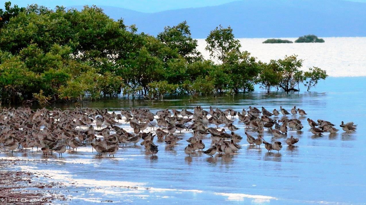
Migratory Shorebirds near Toondah Harbour. Photo by Chris Walker
The massive development proposal for the Toondah coastal wetland precinct, where the ferries leave for North Stradbroke Island, has drawn public attention to the area’s international environmental protections.
This proposal, similar to Raby Bay in the 1980’s, involves large scale dredging and land ‘reclamation’ of mangroves and tidal flats. This new scheme is different from Raby Bay’s sprawling canal estate. What is proposed is a cluster of 40 or 50, up to 10 storey apartment buildings with a total of 3600 units, housing up to 10 000 people.
But what has changed since the Raby Bay development is that in 1993 the Moreton Bay Ramsar site was declared and it includes the Toondah wetlands. It is Ramsar protected wetlands that the developers plan to dredge and reclaim.
It also should be noted that the Queensland Government under Campbell Newman declared the Toondah proposal, on publicly owned land, a Priority Development Area under legislation the Labor opposition had vehemently opposed partly because it removed citizen’s rights that exist under planning laws but also because of the potential ease of granting favours to developers.
Jackie Trad quoted in Hansard in the debate on the 2012 Economic Development Bill said.
“This is an outrageous abuse and concentration of power…. This clause is nothing more than the LNP making a power grab to buy up land to develop it at its will and to give it away to its developer mates.”
It was therefore surprising that the Labor Government of 2015 with Jackie Trad as Deputy Premier and Economic Development Minister, retained the law to create Priority Development Areas. It was then positively alarming when as Economic Development Minister Jackie Trad allowed the number of units to be increased from 800 to 3600. Lang Walker, the well-known Sydney developer and political donor, interviewed in the Australian prior to the announcement of an increase, said he was pushing for an increase to around 1000 units. He did better than expected apparently!
So what is Ramsar? The Caspian seaside resort of Ramsar in Iran was the location of a convention to discuss action to protect world wetlands. The Ramsar treaty was signed by a number of countries with the aim of halting the worldwide loss of wetlands and conserving those remaining, particularly for the protection of waterbirds. Australia was an early signatory and there are now 169 countries who have made the commitment.
The Ramsar convention is an example of a timely and wise environmental decision. Initially wetlands were appreciated as important for their environmental value for human existence, the preservation of biodiversity and retention and management of fish habitats and traditional fishing grounds.
In light of growing scientific knowledge preservation of wetlands may be crucial to future human life. Wetlands provide increasingly necessary purification of waste and pollution. They are also the world’s most effective carbon sinks. Peatlands, of which there are large areas within Stradbroke Island’s Ramsar areas, have been demonstrated to store as much carbon as the world’s forest biomass. Coastal wetlands, including mangroves, tidal flats and seagrass beds, as occur at Toondah, are referred to as ‘blue carbon ecosystems’ and play an important role in carbon sequestration.
Wetlands fortify coastal communities against the impact of climate change. They protect the mainland against sea-level rise and storm surges and reduce the impact of floods, droughts and cyclones. The rapid development of Houston in Texas involved reclamation of large areas of wetland and it is considered that this wetland loss led to widespread flooding during Hurricane Harvey, earlier this year. There are very good reasons for governments and their citizens to respect and enforce the Ramsar protections.
The Moreton Bay Ramsar site was declared in 1993 on the basis of multiple criteria. Six of the possible nine criteria for a Ramsar site were fulfilled including it being one of the largest estuarine bays in Australia and its protection by barrier islands of vegetated sand dunes. The original endangered animal species protected have increased and the list includes six species of turtle, dugong, koalas, the migratory birds, Far Eastern Curlew and Great Knot. Biodiversity in the Moreton Bay site is of note with 43 Shorebird species, also protected under separate International agreements (CAMBA and JAMBA), 355 marine invertebrates, 7 mangrove species with 55 species of algae and 7 seagrasses. Moreton Bay is also crucial as feeding grounds for Green Turtles, feeding and breeding grounds for dugong and high concentrations of Loggerhead Turtles. The existence of 50 000 waterbirds in the Bay is also significant as is the high proportion of the world populations of Critically Endangered Far Eastern Curlews and Grey Tailed Tattlers.
The Ramsar site includes most of the southern bay and mainland coastline and large island areas including Moreton Island and 50% of North Stradbroke. The decision about the boundaries obviously took into account existing uses and so excluded the Port of Brisbane and parts of Stradbroke and, not surprisingly, Raby Bay. It was very important though to provide protection to the mud flats of the western shores. “Most pressure from human activities is being exerted on the western shoreline, which also attracts large numbers of wader species that favour muddy habitats.” (Ramsar Information Sheet). Submissions to the Federal Government which is considering the Toondah proposal’s environmental impacts include one from the Ramsar Secretariat which makes clear that decisions about boundaries were not taken lightly in 1993. The secretariat reminded the Government that areas can only be removed from Ramsar protection in cases of ‘urgent national interests.

Sue Ellen Carew
Foxes continue to be baited in large numbers
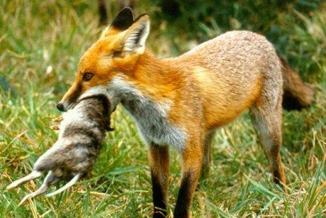
Fox with bandicoot prey
FOSI participated in the North Stradbroke Island Land Pest and Animal Management Working Group meeting held in November at Moreton Bay Research Station. A report on the 2017 fox management program was delivered by Dan Carter from Sibelco with input from Michael Dickinson, Redland City Council, Isaac Burns and David Nalder from Quandamooka Yoolooburrabee Aboriginal Corporation (QYAC) and representatives from Queensland Parks and Wildlife Service (QPWS) – all of these organisations are currently involved with the island’s coordinated fox management program. It is estimated that approximately 300 baits were taken by foxes this season.
Baiting stations were established during winter over four sections of the island (Southern, Central, Northern and Beach). In the northern section 60 camera monitoring stations were set up to monitor wildlife movement for 30 days before and after the baiting programs.
The cameras revealed large concentrations of foxes. In fact, 50% of all fauna recorded by the cameras prior to baiting was foxes! Foxes were particularly concentrated around the Keyholes, the recycling station/dump and Brown Lake. The cameras monitoring the sites following the bait program revealed a very large reduction in the number of foxes in the area.
A trial was also undertaken at several of the Main Beach camping sites which revealed that fox numbers are high around the campsites and a process can be implemented to temporarily close down and bait foxes in these areas.
Planning is already underway for the 2018 fox management plan with SEQ Water on board to participate in the program in the land it manages.
A feral cat control program proposal is also being developed by QPWS which could involve the island participating in a managed trial of Eradicate, the new breakthrough feral cat bait.
Positive Wildlife Impacts
Bandicoots rebounding!
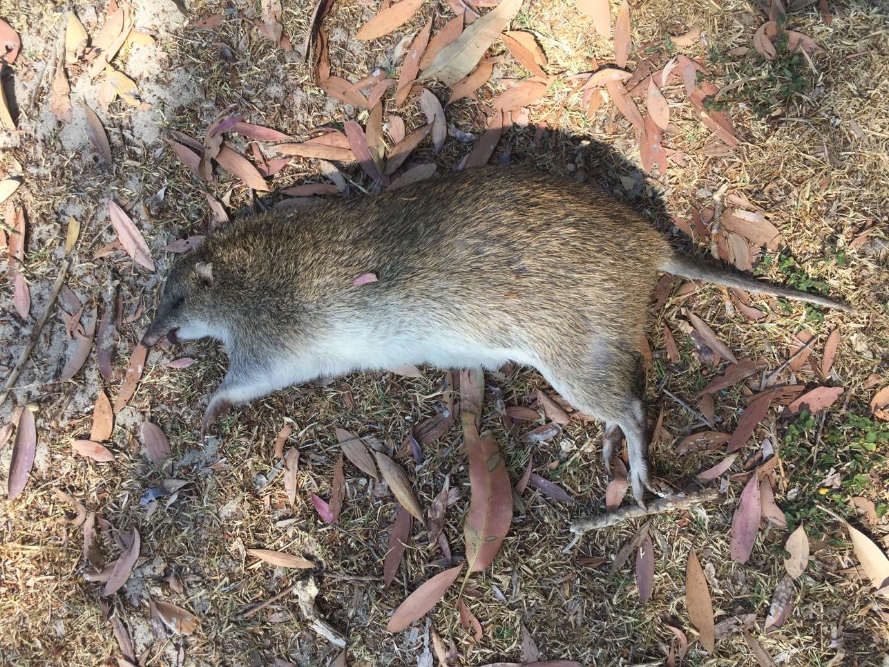
Take care and drive slowly when driving at night - Northern Brown Bandicoots numbers are increasing as foxes are controlled. Sadly, as the bandicoot population has grown wildlife carers are reporting increased numbers hit by cars. This large, mature adult male was found dead on the side of the road across from Home Beach in September 2017. Photo by Mary Barram
A noticeable increase in the population of Northern Brown Bandicoots has been reported around the townships and island. Bandicoots were once common on the island – Oodgeroo writes of them in her accounts of her childhood on the island. Bandicoots are still common on Moreton Island/Morgumpin which is fox-free.
As the animals are nocturnal they are not usually seen – their traces are the holes they dig – up to 10-15 per night which are being increasingly noticed in township gardens and along bush tracks.
Bandicoots, along with echidnas and other digging mammals, are nature’s engineers. The digging and turning over of the soil by these animals is now known to provide important ecological services which improve soil health, water penetration and spread mycorrhizal fungi across the landscape.
These critical symbiotic fungi help plants to increase their absorption of nutrients and deal with our island’s nutrient-poor sandy soils. Digging mammals can also reduce the amount of combustible plant material within a landscape, possibly altering fire regimes. Restoring the island populations of these 'ecosystem engineers' - by controlling foxes as a first step - will have many benefits for the island’s ecology and the recovery of mined land.
Bird numbers – rangers reported that ground bird numbers also appear to be increasing.
Sea turtle nests – three years ago the nests on the island suffered a 50% predation rate by foxes. Thanks to the baiting program and other strategies run as part of the Queensland Turtle Program, coordinated by Jennie Truman on the island, it is believed no nests have been predated in 2016 and 2017.
Ancient Island Cypress trees dated
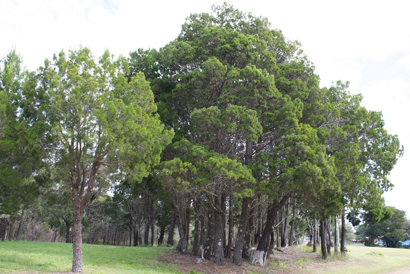
Minjerribah’s ancient Island Cypresses need protection from wildfire and destructive land clearing caused by sandmining and poorly planned ‘development’. Photo FOSI
David Nalder from QYAC presented to the North Stradbroke Island Land Pest and Animal Management Working Group a newly developed Bushfire Management Plan for the island which includes the use of cool, low intensity, burns. As part of the plan’s development, research has been conducted into the age of Island Cypress trees which has shown that some of the large trees are 1,300-1,400 years old!
As Island Cypresses are killed by medium intensity and hot wildfires, the survival of these trees indicates that the island forest has been actively managed with cool burns as part of traditional cultural burning practices over the millennia.
QYAC rangers are mapping the location of these ancient trees in areas near Swan Bay and other parts of the national park and managing the understorey to ensure their ongoing protection from hot wildfires.
The knowledge of the longevity of these ancient trees is yet another reason why the destruction of island forest for sandmining should cease immediately.
Mary Barram
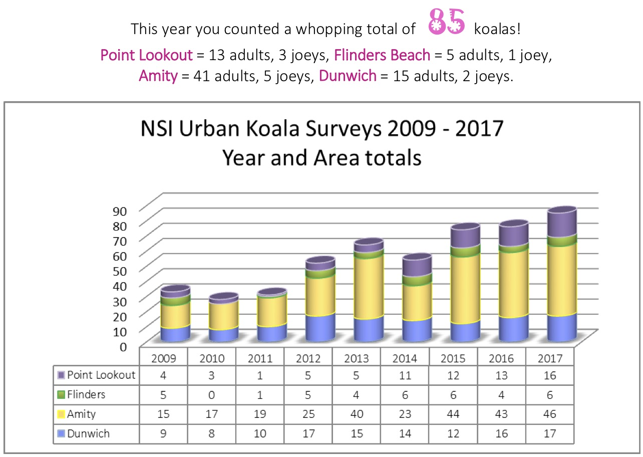
Koala Count 2017

Dunwich Koala on the day of the count. Photo by FOSI
Redland City Council’s Koala count for 2017 was conducted once more only within the boundaries of North Stradbroke Island’s townships, Amity, Point Lookout and Dunwich.
Much more of the island is considered Koala habitat but research is limited and focussed on mining revegetation areas.
This year’s count revealed a further increase in numbers. In previous articles in the FOSI newsletter we have queried whether increasing numbers of Koalas in the island’s urban areas is reflective of destruction of habitat through land clearing for mining activities and this is likely the case and what is certain is that koalas now living in urban areas are at risk from traffic and dogs.
The major rationale for the South-East Queensland Koala being declared as Vulnerable under Federal Environment laws is threats arising from land clearing and habitat destructiion.
On North Stradbroke population estimates will be very difficult until miner Sibelco either permits independent counts on its leases or until it vacates the island landscape and stops the scourge of land clearing.
Koala Action Group
Moreton Bay Water Quality Improves for 2017
This year’s Healthy Land and Water Report Card on the waters of Moreton Bay showed significant improvement. Improving environmental statistics are rather rare these days so this is really good news for the Bay. It would be a big step backwards if the gigantic Toondah project is allowed to go ahead. The dredging and land ‘reclamation’ work that the development would entail will have inevitable negative impacts on the Bay’s water quality and runs the risk of setting a precedent for other developers.
It is interesting to compare this year’s figures with 2016 in the table below:
2016
|
2017
| |
Eastern Bay (including Stradbroke area)
|
A-
|
A
|
Central Bay (including the Toondah /Cleveland area)
|
B+
|
A-
|
Western Bay (including Port of Brisbane area)
|
B
|
B
|
The War on Cane Toads
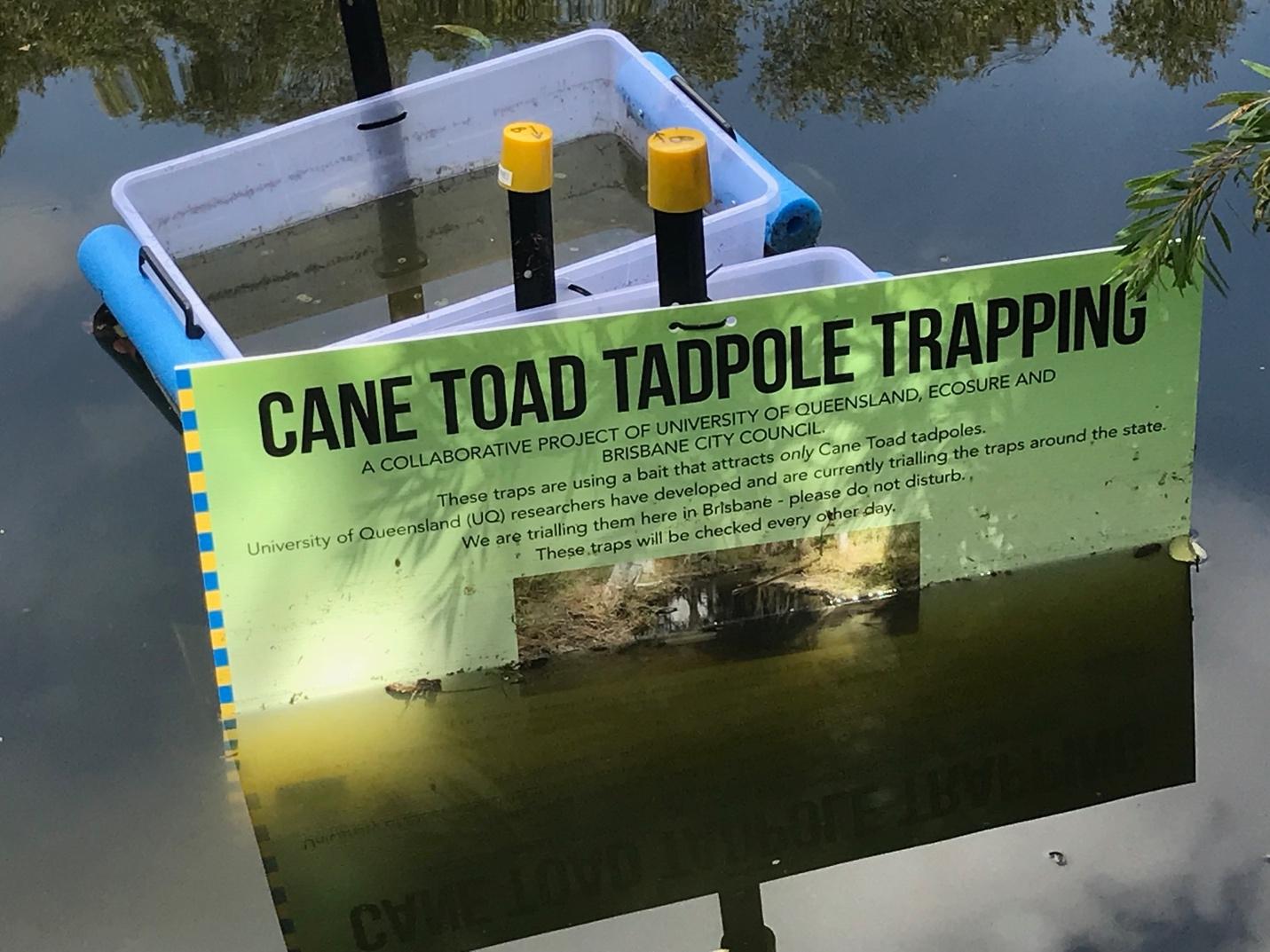
Brisbane City Council's simple Cane Toad tadpole traps in the pond at Mt Coot-tha
Researchers from the University of Queensland’s Institute for Molecular Bioscience have developed a new tool in the quest to eradicate one of Queensland’s most derided invasive pests – the cane toad.
Using simple traps constructed from crates and funnels set to float in managed waterways, such as creeks, dams and ponds, cane toad tadpoles are lured by an attractant, extracted from the glands of adult toads. Captured tadpoles are ‘harvested’ from the traps and disposed of in an environmentally sound and humane manner by ‘cooling and freezing’.
The jury is still out on whether trapping will have widespread effect on the toad population, but it has the potential to remove large numbers of toxic tadpole. In some ecosystems, the removal of competing cane toad tadpoles will clear habitat to the benefit of other aquatic species.
North Stradbroke Island has long had a problem with cane toads which have no doubt had an impact on native animals – native frogs, snakes and goannas are thought to have declined for example. At Cylinder Beach the lagoons that develop, fill with storm water etc. and stagnate have been a prime breeding spot for toads, while Brown Lake is currently suffering a serious infestation. Given Brown Lake is such a treasure house of often rare native frogs and other aquatic species, then the opportunity to eradicate this population should be grasped.
A FOSI representative recently attended a meeting of island land managers, including the Redland Council, National Parks and QYAC (Quandamooka Corporation) where she was able to supply information and put forward the proposal for Stradbroke to join the University’s ‘Cane Toad Challenge’. Gratifyingly there was a strong level of support so we can now look forward to the possibility of some action on invasive cane toads.
Did the Norfolk Great Wave occur on North Stradbroke Island?

For some time I had unsuccessfully sought information from Norfolk Island about the 1834 flood since Geoff Moore from the Dunwich Museum described it. Geoff had read Was it a Legend? where it described my speculation on page 31 how the ship in the Stradbroke Island swamp could have been swept off the beach in early 1835 and that Norfolk Island may have been affected at that time. Geoff described how on 8 May 1834 Kingston on this island had experienced a great ‘flood wave’. The lure was irresistible to me and, on 23.9.2017, Edith and I arrived on Norfolk Island for 7 days. Parallels with Stradbroke Island appeared during this stay.
The 1800 island residents rely almost entirely on their paying guests of the 1000 visitors who appreciate an enthusiastic welcome. This has evolved a community who actively cater for this with interesting accommodation, entertainment and hospitality at surprisingly reasonable prices. To get a quick idea of my bearings the first afternoon I walked from our accommodation, Governor’s Lodge, to the township of Burnt Pine, a distance of about 1.3km. This walk was full of interest with lush gardens and with magnificent mountains of rainforest as a background three kilometres away to the north.
The Norfolk pines were awe-inspiring. I had been familiar with these trees on our coast but took little appreciative notice of them. Here they had been growing in profusion for millennia. Many were over 600 years old and of magnificent dimensions. These were truly noble trees growing in a volcanic soil. Although conserved by law they had also provided their timber to the residents for more than two centuries. This fertile land provided a decay-proof environment for this remarkable pine. It has been used and appreciated for every possible use. Some table-tops were 1.2 metres wide and 50 mm thick without a blemish or a joint. During this walk I purchased a book, Convict Kingston, which described the 1834 flood (page 32).
Later at sunset we took our pre-paid hire car to a nearby restaurant. On arrival, there was a power cut as the sun disappeared and this created an interesting effect. Undeterred we took our window seats with its darkening western vista. The gloom was then relieved by a small lamp and our order was taken and the meal cooked in a gas-fired wok. We were told, as if this was normal, that the quickly passing car was the engineer going to attend the power station. Suddenly the lights came on. We enjoyed the preliminaries and our meal. This set a relaxed and novel theme for our stay where we lived in a commodious separate cottage set with others in lush gardens under those grand trees.
We enjoyed as many of the activities on offer as we could fit in. These included an evening lecture on the Norfolk language, park walks, guided history walks, lectures in which we were encouraged to contribute and progressive dinners to meet our fellow guests and the Pitcairn descendants. We enjoyed the night walk, Wonderland by Night, in the forest where poetry was read by an attractive young girl at suddenly illuminated dioramas along the way.
The businesses of both Norfolk and North Stradbroke Islands are dependent on visitor numbers but the welcoming hospitality and giving outlook of the residents help tourists to appreciate these islands. Both are rich in an equitable climate and a natural environment with a spirit of enterprise and adventure. Both islands were founded in the convict system at a similar time. These Garden of Eden-like islands were a natural wilderness but were a place of torment for these convict men by their conduct to one another. Now Norfolk Island especially but also Stradbroke Island are inhabited by people who are much more appreciative of their fellow visitors and these precious places.
At the Norfolk Island Museum I met Leah Honeywood, a descendant from the Pitcairn pioneers, who willingly provided information on the ‘huge tide’ of 1834 from Aaron Price’s diary. He, as a literate convict, described how on 8 May 1834 ‘the evening wind blowing from the nor’ nor’ west an unusual rise of the sea took place, inundating a great part of the settlement such as the four Stores buildings, Police Office and other structures. The salt house was completely destroyed.’ Here was the flood discovered for me by Geoff Moore.
My Norfolk Island experience at Kingston revealed that it was a tsunami and not the evening wind in 1834 as described by Aaron Price. If it continued to Stradbroke Island on the back bearing of 95¼° it was capable of transporting the ship into the swamp at night.
The force of the wave on 20 February 1835 which, described by me, took the ship into the swamp came from 95¼° east of true north only nine months later (pages 23, 31 and 34 of Was it a Legend?).
Which was the tsunami which affected Stradbroke Island? Is it possible that there were two only under a year apart? More research is obviously called for.
Was the NNW wind on Norfolk Island coincidental or did it have an influence on the flood? The evidence at Pt Lookout indicates that the force of the tsunami described by Charles Darwin came from 95¼° east. This bearing across the Pacific Ocean describes the origin of the tsunami to be Concepcion in Chile? Did it fail to cross the Pacific Ocean?
Duncan McPhee, December 2017
Happy holidays to all FOSI members
See you on the beach and along the bush tracks in 2018.
For Island nature information remember to go to FOSI’S facebook page:
- Friends of Stradbroke island- Minjerribah- Nature Guide
For information on the continuing campaign against wetland destruction at Toondah go to Facebook pages:
- Save Straddie
- Redlands 2030
- Save Our Bay
- Toondah Harbour and Toondah Friends